

Cabrillo National Monument has two documents with which all staff and VIPs should be familiar. The first and most important is the Foundation Document of February 2017: “Every unit of the national park system will have a foundational document to provide basic guidance for planning and management decisions—a foundation for planning and management. The core components of a foundation document include a brief description of the park as well as the park’s purpose, significance, fundamental resources and values, other important resources and values, and interpretive themes. The foundation document also includes special mandates and administrative commitments, an assessment of planning and data needs that identifies planning issues, planning products to be developed, and the associated studies and data required for park planning. Along with the core components, the assessment provides a focus for park planning activities and establishes a baseline from which planning documents are developed.”
Please read the Overview of the Foundation Document that follows. The full document can be found at https://cnmvipvoice.org/wp-content/uploads/2017/08/cabr_foundation_compacted.pdf
The second document is the Long-Range Interpretive Plan of April 2009 which “articulates a vision for the park’s interpretive future, and recommends the media, facilities, and programs best suited for meeting visitor needs, achieving management goals, and telling the park stories.” It describes implementation strategies for how to tell Cabrillo National Monument’s varied stories as highlighted in the Foundation document.
The Long-Range Interpretive Plan can be reviewed at https://npshistory.com/publications/cabr/lrip-2009.pdf
These documents describe the heart and soul of Cabrillo National Monument and outline strategies for how to care for and share the park in ways that will enhance visitors’ experiences while preserving the precious resources here. These strategies center on Cabrillo National Monument’s mission, purpose, resources, significances, themes, and visitor experience goals.
Cabrillo National Monument Mission
The National Park Service at Cabrillo National Monument commemorates Juan Rodriguez Cabrillo’s voyage of exploration and its significance. NPS protects, preserves and manages the monument’s cultural and natural resources and associated values in a manner that leaves them unimpaired while providing a high quality educational and recreational experience for all visitors.
Purpose
The purpose statement identifies the specific reason(s) for establishment of a particular park.
Cabrillo National Monument, on Point Loma at the ocean gateway to San Diego, commemorates Juan Rodriguez Cabrillo’s 1542 voyage of exploration and discovery of Alta California and conserves maritime and military cultural resources and dynamic terrestrial and marine ecosystems.
Significances
Significance statements express why Cabrillo National Monument resources and values are important enough to merit national park unit designation.
- In 1542, Juan Rodriguez Cabrillo became the first European to set foot on and chart the West Coast of what is now the United States, opening the doors for those who followed in exploring the world during the Age of Discovery. This event also marked the advent of a dramatic transformation of indigenous communities and landscapes.
- The Old Point Loma Lighthouse, illuminated in 1855, was among the first eight lighthouses built along the West Coast at that time by the U.S. Lighthouse Board. The lighthouse helped improve navigation and promoted maritime commerce and safe travel along the developing West Coast.
- The extensive rocky intertidal area along the monument’s western boundary and the southern tip of the Point Loma Peninsula contains one of the best-preserved and well-studied mainland Pacific tide pool ecosystems in Southern California.
- Cabrillo National Monument preserves 21 military fortifications, including the only remaining pop-up searchlight, which protected San Diego Harbor and the West Coast during World War I and World War II.
- An isolated yet viable remnant of the rare and sensitive coastal Southern California Mediterranean ecosystem, the Point Loma Peninsula is valued for its distinctive flora, refuge for wildlife, research, and educational opportunities.
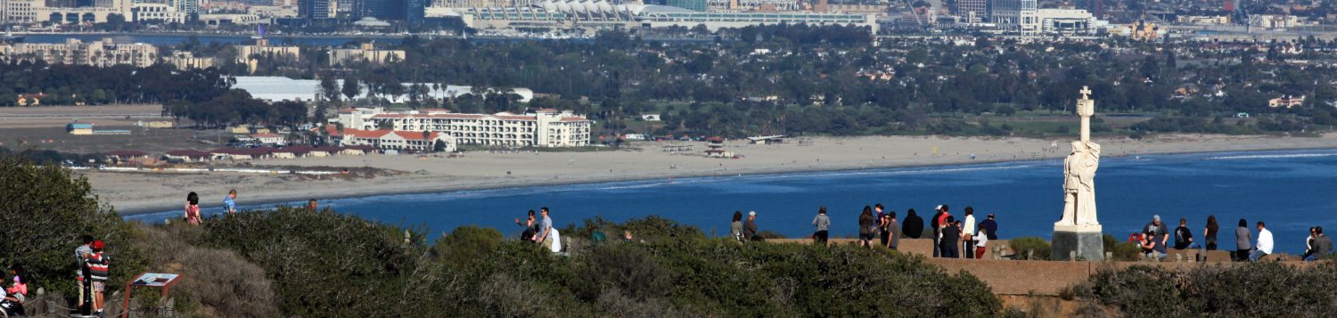
- Perched on a peninsula more than 400 feet above the shoreline, Cabrillo National Monument offers unparalleled panoramic views of the Pacific Ocean and the urban skyline and mountain ranges from San Diego to Mexico.
Resources and Values
Fundamental resources and values are those features, systems, processes, experiences, stories, scenes, sounds, smells, or other attributes determined to merit primary consideration during planning and management processes because they are essential to achieving the purpose of the park and maintaining its significance.
- Cabrillo Commemoration/Statue. Since its establishment in 1913, the primary purpose of Cabrillo National Monument has been the commemoration of Captain Juan Rodriguez Cabrillo’s voyage of exploration and discovery that notably led to the expedition’s discovery on September 28, 1542, of the harbor that Cabrillo named Puerto de San Miguel—today’s San Diego Harbor. The expedition laid the foundation for subsequent Spanish explorations and claims to Alta California and supported the nation’s trade with the Philippines and its other East Indian colonial possessions. An original statue of Cabrillo was created by the Portuguese sculptor Alvaro de Bree in 1939 and donated to the United States by the citizens of Portugal. The statue was placed near the lighthouse and was dedicated on September 28, 1949. In 1966, it was moved to a promontory overlooking the entrance to San Diego Bay. However, the porous limestone used for the statue deteriorated with exposure to the elements on Point Loma, and it was removed and placed in storage. Portuguese sculptor Joao Charters Almeida, using a harder limestone, subsequently created a new statue that reproduced the shape and color of the original. The statue was transported by the Portuguese Navy to San Diego and was dedicated on February 28, 1988. It retains strong cultural importance for the Portuguese community of San Diego and California.
- Tide Pools / Marine Ecosystem (Intertidal Zone). The extensive rocky intertidal area along the monument’s western boundary and the southern tip of the Point Loma Peninsula contains one of the best-preserved, mainland Pacific tide pool ecosystems in Southern California. This area, protected by NPS staff and volunteers, provides unique opportunities for the public, academic groups, and researchers to observe and study a local marine community similar but also distinctly different from communities south through Baja California and Baja California Sur, Mexico, and north to Point Conception, California.
- Old Point Loma Lighthouse. The Old Point Loma Lighthouse, constructed in 1854 at the highest point on Point Loma, was one of eight lighthouses authorized by Congress that were constructed between 1852 and 1854 along the West Coast of the United States. Upon installation of a Fresnel lens, the Old Point Loma Lighthouse was put into service in November 1855. The lighthouse operated for 36 years under the oversight of 11 keepers and 22 assistants. Robert D. Israel and his wife Maria lived at the lighthouse from 1871 to 1891, and the current restoration and furnishings of the lighthouse reflect their tenure at the site. Coastal fog and low clouds frequently limited the effectiveness of the lighthouse, and it was replaced by a new light station built in 1891 at the southern tip of Point Loma that is currently managed by the U.S. Coast Guard. The U.S. Navy occupied the Old Point Loma Lighthouse as a command post and signal station during World War II. The lighthouse is identified as nationally significant in the National Register of Historic Places.
- Military Harbor Defenses. Point Loma was designated a U.S. military reserve in 1852, strategically positioned to protect the entrance to San Diego Bay. The War Department dedicated the site as Fort Rosecrans in 1899 and over the years constructed a series of gun batteries and other military installations. Between World Wars I and II, the U.S. Army constructed searchlight bunkers, fire control stations, a radio station, and gun batteries on Point Loma as part of the coastal and harbor defense system. The largest guns were deployed at Battery Ashburn where two 16- inch guns were capable of firing 2,300-pound shells nearly 30 miles out to sea. Many of these former military features remained in active service until 1950. This military complex extends beyond the monument’s northern boundary on the Pacific Ocean side, around the tip of Point Loma, and to the northern boundary of the federal reservation on the bayside. The monument’s 19 surviving military structures and features are listed in the National Register of Historic Places, identified as regionally significant contributing historic structures.
- Scenic Views. The outstanding scenic opportunities provided from the crest of Point Loma have long drawn people to experience panoramic views of the ocean, offshore islands, distant mountain ranges, and the city and harbor of San Diego. Apart from their purely recreational appeal, views from Point Loma were valuable for military observation and defense, as a place to watch for incoming ships, and as a vantage point for whalers to watch for migrating whales. The prominent exposed location also made it a highly visible spot, an important consideration for selection of the Old Point Loma Lighthouse site. Scenic views and vistas continue to be a primary objective for visitation to the monument, and viewing opportunities are provided at the lighthouse, Visitor Center, the Kelp Forest/Whale Watch Overlook, and other key vantage points. The area is also known for having some of the best dark night skies providing opportunities for the visitor to enjoy views of the night sky.
- Terrestrial Ecosystem. Point Loma’s coastal Mediterranean ecotype supports some of the few remaining protected stands of native plant communities: coastal sage scrub, maritime succulent scrub, southern maritime chaparral, southern coastal bluff scrub, and southern foredune scrub. These communities are considered sensitive or extremely endangered because development has eliminated more than 70% of the coastal Mediterranean ecotype in Southern California. A prominent ridgeline that runs the length of the Point Loma Peninsula, although disturbed by development, plays a significant role in defining the distribution of plant communities. The peninsula’s rare plant communities are home to a wide variety of native wildlife including mammals, birds, amphibians, and reptiles.
- Visitor Center Historic District. The Cabrillo National Monument Visitor Center Historic District (visitor center historic district) was constructed in 1963–1967 as part of the NPS Mission 66 program. The NPS-wide design and construction program of the 1950s and 1960s incorporated modern design and construction elements to meet the growing demands of the motoring public for updated monument facilities. The visitor complex consists of three separate buildings connected by covered breezeways and terraces: (1) the view building (a glass-walled pavilion offering commanding views of the San Diego coast), (2) the exhibits/auditorium building, and (3) the administration building. In addition to the visitor center buildings and their associated overlook terraces, the other primary components of the historic district include the Cabrillo Memorial Statue Overlook, the Ballast View Overlook, an entry drive and a large central parking lot, a series of pedestrian pathways, and plantings that provide a transition between the designed landscape and the natural landscape. Despite some alterations to the buildings and setting, the historic district retains a high degree of historic integrity reflecting the design and planning intent of the Mission 66 era.
- Geologic Resources. Point Loma’s primary geological formations were created by the uplift of deep water ocean “submarine fans” composed of sedimentary deposits that formed during the late Cretaceous period (about 76 million years ago). These fossil-bearing formations consist of the Cabrillo Formation (sandstone and conglomerate) overlying the Point Loma Formation (sandstone and mudstone). Among the geologic features at the park are paralic (“by the sea”) deposits formed by beach, estuarine, and colluvial deposition; uplifted marine terraces; Rose Canyon Fault Zone that has caused the uplift of the Point Loma Peninsula and the drop of San Diego Bay; and coastal erosion features such as sea cliffs and sea caves. Storm waves further contribute to the erosion and slumping of cliff faces. Wind-related (aeolian) processes of erosion and deposition have also shaped the landscape of the Point Loma Peninsula. Plant and animal habitats have evolved along with aeolian features and processes, which continue to influence soil formation and distribution of particular species. The Cretaceous bedrock serves as the substrate for the monument’s tidal pools, kelp forests, and reefs.
Major Park Themes
Interpretive themes are often described as the key stories or concepts that visitors should understand after visiting a park
- In 1542, Juan Rodriguez Cabrillo became the first European to explore and chart the West Coast of what is now the United States, extending the domain of New Spain and opening the doors for explorers that followed and changing the world of the indigenous people of the region.
- As one of the first eight lighthouses built by the U.S. Lighthouse Establishment on the West Coast, the Old Point Loma Lighthouse helped improve navigation and promoted maritime commerce and safe travel in the developing West.
- The regionally significant rocky intertidal habitat at Cabrillo National Monument is protected and valued for its public access, research potential, and educational opportunities.
- The U.S. Army coastal defense systems that protected San Diego are part of our national heritage and represent the universal human desire to protect values, families, and ways of life.
- An isolated but viable remnant of the sensitive coastal Southern California Mediterranean ecosystem is being preserved on the Point Loma Peninsula and is valued for its public access, research potential, and educational opportunities.
- The terrestrial and marine resources in and adjacent to Cabrillo National Monument are inextricably connected to and affected by human influence; their condition requires protection, preservation, interpretation, and restoration to enhance them.
Visitor Experience Goals
- Cabrillo National Monument’s natural and cultural resources and scenic values are protected, restored and maintained in good condition and managed within their broader ecosystem and cultural context.
- The National Park Service at Cabrillo National Monument contributes to the knowledge of Point Loma’s natural and cultural resources and its associated values; management decisions about resources and visitors are based on adequate scholarly and scientific information.
- Visitors to Cabrillo National Monument safely enjoy and are satisfied with the availability, accessibility, diversity and quality of park facilities, services and appropriate resource-based recreational opportunities.
- Park visitors and the general public understand and appreciate the significance of Cabrillo National Monument and support the preservation of its resources and values for this and future generations.
- Park employees at Cabrillo National Monument work in a safe and supportive environment and use current management practices, systems, and technologies to accomplish the park mission.
- The National Park Service at Cabrillo National Monument increases its managerial capabilities through initiatives and support from other agencies, organizations, and individuals.
Last revised 19-May-26
